I love the narrow, roomy feeling you get when the sea pulls back and exposes reefs, rock pools and shards of sand. The walk from Balnakeil to Enamel Bay is one of those small Highland rituals that feels secret until you know the tide beat and the safe line of travel. I’ve done this walk many times at low tide and learned the hard way that the coast looks very different an hour later. Below I’ll share how I plan the route, the tide windows I use, key landmarks, where hikers commonly go wrong, what to carry, and safe alternatives if the tide or weather isn’t playing ball.
Why timing matters here
The strand between Balnakeil and Enamel Bay is a mix of firm sand, rocky headlands and shallow channels that fill quickly. On a spring tide the water can reclaim the flats very fast and cut you off against steep grassy slopes. I always treat this stretch as a tidal route rather than a coastal path: you must plan around tide tables and allow big safety margins.
Before you go: essential planning
Check the tide for Durness/Port of Durness on a reliable site or app (I use the UK Hydrographic Office or Magic Seaweed for swell info). Convert the high/low times to your local clock, and note the low tide time. I aim to be on the flats at least one hour after low tide when retreating channels are at their shallowest. If you arrive an hour before low tide you risk returning across soft mud that’s still draining.
- Check the weather forecast — wind direction matters. Onshore winds can push higher water levels into bays and channels.
- Tell someone your plan and estimated return time. Single-track phone signal is patchy; leave a note in your car if you can.
- Carry a map (Ordnance Survey Landranger 9 or Explorer OL maps), compass and a charged phone. A handheld GPS or the OS Maps app is very useful.
- Pack waterproofs, warm layers, and spare socks — wet feet happen even on firm sand.
Where to start and park
Park at the Balnakeil car park near the church and dunes — there’s a small free car park used by walkers. From the car park head down toward Balnakeil Beach and the whitewashed Balnakeil House ruins; the path heads west along the dunes and then drops to the sand. There is also a small access track off the A838 near the Balnakeil craft village if you’re coming from the east.
How I pick the safest window
Think of the tide window like this: low tide is the point of maximum clearance; start crossing the flats no earlier than 30–60 minutes after low tide, and aim to be off the most exposed sections before the water has had time to rise significantly. On neap tides the safe window is wider — perhaps 2–3 hours after low — while on spring tides the safe window can narrow to 30–90 minutes.
| Condition | Safe window (after low tide) |
|---|---|
| Spring tide (big swing) | 30–90 minutes |
| Neap tide (small swing) | 1–3 hours |
| Strong onshore wind | Reduce window by 30–60 minutes |
Note: these are general guides — always check actual tide heights. If in doubt, don’t go. It’s easy to underestimate how quickly channels can refill.
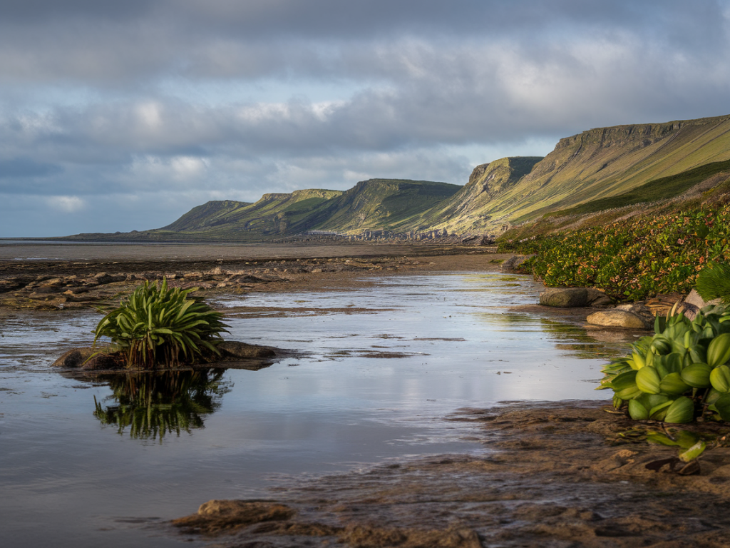
Route description with landmarks
From Balnakeil Beach walk west along the firm sand toward the rocky point at the western end. You’ll pass seaweed-strewn flats and occasional channels. The main features to watch for:
- Balnakeil River mouth — a shallow channel that often splits and reforms; cross where it’s widest but shallowest, aiming for smooth sand between channels.
- Flat sandy bay — easy walking, but check for soft patches. Test with a pole or trekking pole tip before committing.
- Rocky headlands — these are where tidewater returns fastest. When you reach the first rocky promontory, look back and note how much sand remains between you and the high-water mark.
- Small channels near Enamel Bay — shallow on average but can cut deep ruts; use the rock platforms where possible to bypass them.
When the sand runs out before Enamel Bay you’ll have to either pick your way over rock shelves or climb a short grassy spur inland. I prefer to stay low and follow the rock ledges where they are dry and continuous — they give a reliable, fast route. Avoid clambering on seaweed-covered rocks; they’re deceptively slippery.
Common mistakes and how to avoid them
People get cut off here by misreading channels, following footprints that lead into soft sand, or leaving too little margin for onshore wind. I’ve also seen walkers attempt to hug the cliffs where collapse or unstabled turf is a real hazard. My advice:
- Follow the sand where possible — it’s faster and more predictable than pothole-strewn rock strips.
- Use a trekking pole to test firmness in questionable sand or mud.
- If you see water filling a channel ahead and you’re unsure of the depth, retreat to higher ground early rather than trying a blind crossing.
- Don’t follow others blindly — the best line can change hour to hour with the tide.
Gear I recommend
Over the years I’ve refined a lightweight kit that keeps me safe and dry:
- Sturdy waterproof walking boots (Salomon X Ultra or similar) with ankle support — I don’t recommend trainers unless you accept wet feet.
- Trekking poles — invaluable for testing sand and balancing on rock ledges.
- Waterproof jacket and overtrousers — Scottish weather changes fast.
- Dry bag for phone, map and snacks (Ortlieb is a brand I often use).
- Headlamp — I always carry one in case tide or weather delays my return.
Wildlife and etiquette
This stretch supports waders, oystercatchers and overwintering geese — on some days you’ll see seals hauled out on rocks. Keep dogs on a lead during bird-breeding and wintering seasons and avoid disturbing flocks and roosting birds. Leave no trace: pack out what you bring and be mindful of fragile dune vegetation when leaving or rejoining footpaths.
If you get cut off
If water rises faster than expected and you’re trapped against a slope, look for the highest rock ledge or grassy terrace and move there. Do not attempt to swim across fast channels. Use your phone to call 999 and ask for the coastguard if you are in immediate danger. If your device has poor signal, try walking to higher ground slowly and calmly to seek reception. Stay together and conserve warmth; change into dry layers if available.
Alternatives if the tide or weather is wrong
If the tide window is too tight or the wind is strong, postpone and opt for one of my favourite alternatives: the cliff-top path from Balnakeil towards Sango Sands and Durness. It’s longer but entirely safe from tides and offers huge views. Or head east from Balnakeil into the machair for a quiet beach stroll — same dramatic light, none of the tidal timing stress.
Finally, remember that part of the joy of walking here is learning to read the coast. Take your time, respect the tide, and the Balnakeil–Enamel Bay stretch will reward you with wildlife, quiet sands and a very particular Highland hush.