I lead this low-tide walk to Sango Sands sea caves often when the sky is crisp and the tide timetable lines up—there’s nothing like the hush inside the caves after a day of wind and surf. Below I share a practical, step-by-step route from the Sango Sands car park, with clear tide safety advice, what to carry, best photo spots, and small local notes to help you enjoy the coast responsibly.
Why this walk is special
Sango Sands is one of those places where geology, light and wild weather combine to create dramatic scenes: sea stacks, arches and a sweep of white sand backed by steep cliffs. The sea caves along the north shore reveal themselves only at low tide, and moving through them feels like discovering a secret. I stick to low-tide windows not out of drama but for safety—these caves can trap the unwary when the tide turns fast.
When to go: timing and tide windows
The single most important rule: only enter the caves when the tide is falling and well below the level of the cave floor. Check reliable tide tables for Durness or nearby ports (the Met Office and local harbour websites are good). Aim to arrive at least 90 minutes before high tide and give yourself a wide margin—I usually plan to be off the beach 1.5–2 hours before the predicted high tide.
- Best window: 2–3 hours either side of low tide (centre your visit on low tide).
- Avoid: times when the swell is large or when storm surges are forecast.
- Evening light: low tide around late afternoon gives stunning warm light but requires a torch or headlamp for the return if it gets dark.
Getting there and start point
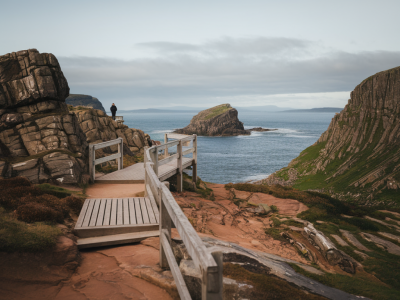
Start at the Sango Sands car park (grid ref: NC381669 if you use OS maps). There are public toilets at the campsite during the season and a small shop nearby for last-minute snacks. From the car park, follow the signed path toward the beach. The path is well-trodden but can be boggy after rain; I wear mid-height waterproof boots for the approach and change into lighter footwear for the beach when dry.
Step-by-step route
The route below assumes a start from the car park and a falling tide. I describe approximate times for a relaxed walker stopping for photos.
- 0–10 minutes: Follow the path to the dunes and descend to Sango Sands beach. Take a moment on the dunes to look back—on clear days you can see across the bay to the cliffs near Balnakeil.
- 10–25 minutes: Walk along the firm sand toward the northern end of the beach. Keep the high tide mark on your left; there’s plenty of room at low tide but avoid cliffs and obvious wet patches.
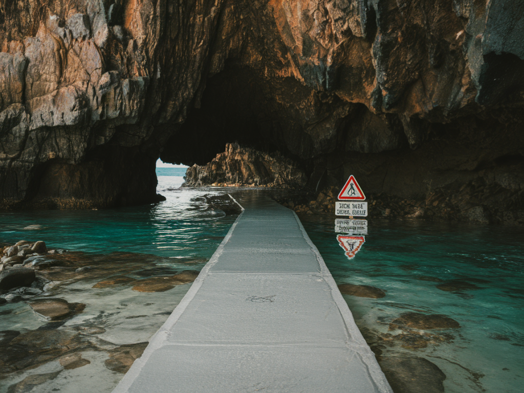
- 25–40 minutes: Reach the southern entrance to the sea caves near the headland. If the tide is still high or the swell big, stay on the open beach—do not attempt to enter. When safe, step into the first arch and continue along the cave corridor. The floor can be uneven—watch for seaweed-covered rocks.
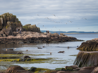
- 40–70 minutes: Explore the caves, arches and small hidden coves. I leave time to sit quietly and watch for seals bobbing or birds calling from cliff ledges. Use a headlamp if any sections look dark—natural light can be deceptive.
- 70–90+ minutes: Retrace your steps back to the beach, keeping an eye on the tide line. Aim to be back on the main stretch of sand with at least 90 minutes before high tide predicted, adjusting if the sea is rougher than expected.
Tide safety essentials
Tides here can rise quickly and the entrance points to the caves can be cut off. Follow these safety practices I use every time:
- Plan with tides: Print or screenshot tide times for the day and double-check wind and swell forecasts.
- Set a turnaround time: Decide your latest return time and stick to it—don’t extend for “one more photo”.
- Keep to open sand routes: If you see lines of seaweed or wet sand advancing, move away from the cliff base.
- Tell someone: Let a friend, your B&B host, or the campsite know your plan and expected return time.
- Carry a phone and power: Keep your phone in a waterproof case and carry a small power bank.
- Consider a handheld VHF or PLB: If you’re out in poor weather or alone, these are sensible additions.
Gear and what I carry
My kit for this walk is deliberately light but practical:
- Waterproof hiking boots (or sturdy trainers for dry days)
- Waterproof jacket and an insulating mid-layer (weather changes fast)
- Headlamp or torch (with spare batteries)
- Phone in a drybag, plus a small power bank
- Map or downloaded OS map on a smartphone app (I use OS Maps)
- Basic first-aid, whistle and a small snack
- Camera with a wide-angle lens (I like a 16–35mm for caves) and a compact tripod for low-light shots
Photography tips
The cave interiors are tempting but tricky. I use a tripod and a wide aperture for longer exposures, or raise ISO carefully to avoid blur if I’m handheld. Late afternoon sometimes produces warm shafts of light through arches—wait for the sun to be lower for that golden rim-light on spray. For dramatic compositions, include a foreground rock to give scale to arches and stacks.
Wildlife and quiet moments
Seals, fulmars, and sometimes otters are regulars. Move slowly and keep distance—use a telephoto lens (200–400mm) for intimate shots without disturbing animals. I always remind readers to avoid nesting ledges in spring and early summer when birds are most vulnerable.
Local notes and access etiquette
Respect crofting land and follow the Scottish Outdoor Access Code: take litter home, keep dogs under control near livestock and nesting birds, and avoid disturbing dunes and vegetation. The small caravan site and local businesses appreciate visitors who treat the area with care—stop at the local cafe if you can; it's a great way to support the community and warm up after a breezy walk.
Quick reference tide checklist
| Item | Action |
|---|---|
| Tide times | Check, screenshot, and set alarms for low tide and your turnaround time |
| Wind & swell | Confirm calm-to-moderate swell on local forecasts |
| Visibility | Avoid cave entry in fog or heavy rain |
| Companions | Let someone know your plan and carry a means to call for help |
If you want an annotated GPX of the route or current tide-friendly time windows, drop me a message via Hillside Durness Co (https://www.hillside-durness.co.uk) and I’ll share the latest notes—I update routes seasonally and after any big storms. Above all, take your time: this coast rewards slow, careful exploration.